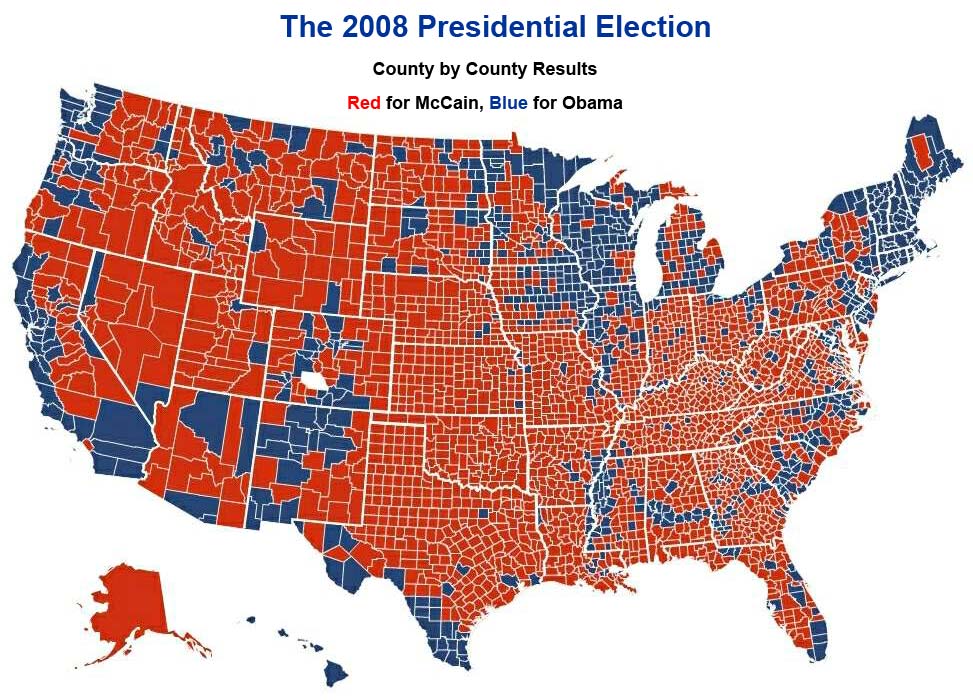
It is interesting. Though, more interesting would be the actual percentages. I'm amused by a state or a county or a district being named blue or red when the percentages are often in the 55 - 45 % range.
I've bee having interesting discussions with my honors freshman about this issue as we read To Kill a Mockingbird. Before the unit begins, I ask them individually and then in groups to write down everything they know about the subject "Alabama in 1930s." Interestingly, the board is soon filled with details that, when analyzed, boil down to "poor, redneck, racist farmers." As we begin to look at prejudice, I remind them of their "stereotype" of the south. Aren't there any fair, just, hardworking family men who are doctors in the South?
Should we, I ask them about the electoral map, infer that all these people in the north who voted for Obama are open-minded and all these red states are filled with bigots? Of course not, they realize. There is great diversity, and people vote based on numerous reasons - cultural, economic, emotional, historical, political, ideological, etc.
Oklahoma was the only pure red state, yet most of New England is pure blue. It's also amazing how Obama was able to win Indiana just by getting a few key counties.
I would hope that the RNC recognizes and responds to the fact that this map shows that a majorty of the nation is made up of small towns who hold onto conservative ideals. For instance, according to the map California could be divided into two states: Southern-Left California (the whacko California made popular in the media) and Center-Right California (the Central Valley, whose industry is being decimated by enviro-socialist utopians in Sacramento). We in the red counties voted for McCain because he did get it: Country First, UN when they get their act together, maybe.
Thats a good graph. Counties sized by population and coloured by %age vote. As is often the case, the rural areas are more red, the urban ones more blue.
> The majority of the (voting part of the) country is made up of people who voted AGAINST McCain.
So does that mean they've now passed the British tabloid intelligence test?
As I recall those were the same people who excited the head line "How could 59 million people be so stupid?" having unaccountably rejected the bids of two of the princes of the House of Left for the throne, uhh, presidency.
Perhaps an offsetting head line, by way of apology, along the lines of "How did 63 million Americans get so smart?" is in order the pleasures of condescension being, I believe, all but irresistible to the superior?
Note the interesting blue counties on almost the entire border to the south. And in Miami as well. Frankly, the media is trying to frame this election as a mandate, but I'm not seeing it that way.
I loved this map! It came at the perfect time... I was teaching a lesson today on how people can putz around with graphs to make them look the way they want. (Prealgebra, standard SDAP 1.1!) AKA, 'Persuasive Graphs'
This was an EXCELLENT example about how land won did not equal votes won, and how if you show your data in different forms, you can come up with drastically different assumptions. (IE, Histogram showing votes vs. this map of all the votes, etc.)
I also had a number of students asking me how Obama could have won, given all the counties that went McCain... which let me talk about how data could be used for the candidates to make decisions about where to spend their time/money when campaigning. (The kids were so interested in it - 12 and 13 year olds.) That they were asking for passes to the library for lunch, so they could start looking up WHY certain areas trend in certain directions... and why our county doesn't follow usual patterns. (I wasn't going to theorize on that. I just said if they wanted to know, they'd have to look up the cultural, social, and economic trends of the areas.)
Q: Bob Novak, is 51 percent of the vote really a mandate?
NOVAK: Of course it is. It's a 3.5 million vote margin. But the people who are saying that it isn't a mandate are the same people who were predicting that John Kerry would win. ... So the people who say there's not a mandate want the president, now that he's won, to say, Oh, we're going to accept the liberalism that the -- that the voters rejected. But Mark, this is a conservative country, and it showed it on last Tuesday.
Ohhh sorry! That was from 4 years ago.. obviously 51% was a mandate back then... but is 52.7% a mandate?
When Franklin D. Roosevelt won his second term for president in 1936, the defeated Republican candidate, Gov. Alf Landon of Kansas, won only two states, Maine and Vermont, and Democrats controlled both houses of Congress by wide margins.
But Obama's win was nothing like that. He may have opened the door to enactment of the long-deferred liberal agenda, but he neither received a broad mandate from the public nor the needed large congressional majorities.
Land versus people, densely versus sparsely populated, urban/suburban versus rural, majorities and mandates, center-right or center-left, rich states versus poor states, high GDP versus low GDP, marriage versus divorce rates, contributors to state and federal aid versus consumers of state and federal aid, traditional versus progressive, etc., etc., etc.
Postings like this are the reason I regularly check your site. Keep up the great news hunts and intriguing postings.
In Nebraska, the electoral votes are split based on how many votes each candidate gets - it's not a winner take all scenario. Maybe more states should look at this given the map.
Nice to be back at your site, great blog. We exchanged posts 4 years back when my wife PCSed to Germany and we put our kids in the German school. Sorry to have lost track of your site and the exchange, but we got busy traveling and enjoying life overseas.
Thanks for the welcome. I don't think any state will reform with either party in control. A true bipartisan group would be needed to set up a system like this, or even repairing racially designed congressional districts. On another note, did you ever look into teaching in England for a year? Have you considered teaching in the DODDS system for the bases overseas? They get better benefits than the military members (higher housing, pay, and COLA; free flight home in the summer) plus the travel is fantastic. Being prior military, you'd be a welcome teacher - one who understands the military family. And life overseas is really nice - even beyond the better beer.
I'd have done it if I could have taken my son with me for part of the time, but his mom still hasn't cut the umbilical cord. I'll consider it again after he graduates, even though I'll be pretty long(er) in the tooth by then....
It is interesting. Though, more interesting would be the actual percentages. I'm amused by a state or a county or a district being named blue or red when the percentages are often in the 55 - 45 % range.
ReplyDeleteI've bee having interesting discussions with my honors freshman about this issue as we read To Kill a Mockingbird. Before the unit begins, I ask them individually and then in groups to write down everything they know about the subject "Alabama in 1930s." Interestingly, the board is soon filled with details that, when analyzed, boil down to "poor, redneck, racist farmers." As we begin to look at prejudice, I remind them of their "stereotype" of the south. Aren't there any fair, just, hardworking family men who are doctors in the South?
Should we, I ask them about the electoral map, infer that all these people in the north who voted for Obama are open-minded and all these red states are filled with bigots? Of course not, they realize. There is great diversity, and people vote based on numerous reasons - cultural, economic, emotional, historical, political, ideological, etc.
Oklahoma was the only pure red state, yet most of New England is pure blue. It's also amazing how Obama was able to win Indiana just by getting a few key counties.
ReplyDeleteI would hope that the RNC recognizes and responds to the fact that this map shows that a majorty of the nation is made up of small towns who hold onto conservative ideals. For instance, according to the map California could be divided into two states: Southern-Left California (the whacko California made popular in the media) and Center-Right California (the Central Valley, whose industry is being decimated by enviro-socialist utopians in Sacramento). We in the red counties voted for McCain because he did get it: Country First, UN when they get their act together, maybe.
ReplyDeleteWhy do you find this interesting?
ReplyDeletehttp://www-personal.umich.edu/~mejn/election/2008/countycartpurple512.png
ReplyDeleteThats a good graph. Counties sized by population and coloured by %age vote. As is often the case, the rural areas are more red, the urban ones more blue.
Seems pretty normal to me...
ReplyDeleteAnd no.. anonymous. The majority of the (voting part of the) country is made up of people who voted AGAINST McCain.
ReplyDeleteTake a look at this graph:
ReplyDeletehttp://graphics8.nytimes.com/packages/flash/politics/20081104_ELECTION_RECAP/electionChange2.swf
This actually shows how each given county voted compared to last year - more blue or more red...
I *love* cartograms and maps in general. And in that spirit may I suggest:
ReplyDeletehttp://strangemaps.wordpress.com/
> The majority of the (voting part of the) country is made up of people who voted AGAINST McCain.
ReplyDeleteSo does that mean they've now passed the British tabloid intelligence test?
As I recall those were the same people who excited the head line "How could 59 million people be so stupid?" having unaccountably rejected the bids of two of the princes of the House of Left for the throne, uhh, presidency.
Perhaps an offsetting head line, by way of apology, along the lines of "How did 63 million Americans get so smart?" is in order the pleasures of condescension being, I believe, all but irresistible to the superior?
Blue is where there are more people than trees. People vote; land does not.
ReplyDeleteNote the interesting blue counties on almost the entire border to the south. And in Miami as well. Frankly, the media is trying to frame this election as a mandate, but I'm not seeing it that way.
ReplyDeleteI loved this map! It came at the perfect time... I was teaching a lesson today on how people can putz around with graphs to make them look the way they want. (Prealgebra, standard SDAP 1.1!) AKA, 'Persuasive Graphs'
ReplyDeleteThis was an EXCELLENT example about how land won did not equal votes won, and how if you show your data in different forms, you can come up with drastically different assumptions. (IE, Histogram showing votes vs. this map of all the votes, etc.)
I also had a number of students asking me how Obama could have won, given all the counties that went McCain... which let me talk about how data could be used for the candidates to make decisions about where to spend their time/money when campaigning. (The kids were so interested in it - 12 and 13 year olds.) That they were asking for passes to the library for lunch, so they could start looking up WHY certain areas trend in certain directions... and why our county doesn't follow usual patterns. (I wasn't going to theorize on that. I just said if they wanted to know, they'd have to look up the cultural, social, and economic trends of the areas.)
So... yeah. Good map ;)
Regions of higher population voted blue and those of less densely populated areas voted red. Seems pretty clear with the provided map.
ReplyDeleteIs it a mandate? Lets see..
ReplyDeleteQ: Bob Novak, is 51 percent of the vote really a mandate?
NOVAK: Of course it is. It's a 3.5 million vote margin. But the people who are saying that it isn't a mandate are the same people who were predicting that John Kerry would win. ... So the people who say there's not a mandate want the president, now that he's won, to say, Oh, we're going to accept the liberalism that the -- that the voters rejected. But Mark, this is a conservative country, and it showed it on last Tuesday.
Ohhh sorry! That was from 4 years ago.. obviously 51% was a mandate back then... but is 52.7% a mandate?
When Franklin D. Roosevelt won his second term for president in 1936, the defeated Republican candidate, Gov. Alf Landon of Kansas, won only two states, Maine and Vermont, and Democrats controlled both houses of Congress by wide margins.
But Obama's win was nothing like that. He may have opened the door to enactment of the long-deferred liberal agenda, but he neither received a broad mandate from the public nor the needed large congressional majorities.
Great topic for discussion, Darren.
ReplyDeleteLand versus people, densely versus sparsely populated, urban/suburban versus rural, majorities and mandates, center-right or center-left, rich states versus poor states, high GDP versus low GDP, marriage versus divorce rates, contributors to state and federal aid versus consumers of state and federal aid, traditional versus progressive, etc., etc., etc.
Postings like this are the reason I regularly check your site. Keep up the great news hunts and intriguing postings.
The *only* reason? You mean my intellect and witty banter isn't enough? Ouch!
ReplyDeleteIn Nebraska, the electoral votes are split based on how many votes each candidate gets - it's not a winner take all scenario. Maybe more states should look at this given the map.
ReplyDeleteNice to be back at your site, great blog. We exchanged posts 4 years back when my wife PCSed to Germany and we put our kids in the German school. Sorry to have lost track of your site and the exchange, but we got busy traveling and enjoying life overseas.
Tom
Welcome back :-)
ReplyDeleteCalifornia will never make such a change as long as the state can be counted on to vote for the Democrat.
Thanks for the welcome. I don't think any state will reform with either party in control. A true bipartisan group would be needed to set up a system like this, or even repairing racially designed congressional districts.
ReplyDeleteOn another note, did you ever look into teaching in England for a year? Have you considered teaching in the DODDS system for the bases overseas? They get better benefits than the military members (higher housing, pay, and COLA; free flight home in the summer) plus the travel is fantastic. Being prior military, you'd be a welcome teacher - one who understands the military family. And life overseas is really nice - even beyond the better beer.
I'd have done it if I could have taken my son with me for part of the time, but his mom still hasn't cut the umbilical cord. I'll consider it again after he graduates, even though I'll be pretty long(er) in the tooth by then....
ReplyDelete